|
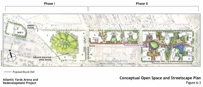
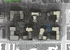
Whimsical Concept Drawing of Lush Landscaped "Open Space" within the Project's Grounds - magically grown without sunlight
|
|
|
|
|
Ratner's proposal offers this fanciful illustration of make-believe parkland within the development, which at first glance looks like a map of Disneyland. The majority of these "parks" for the general public will not be completed until 2016 at the earliest, that is if the project's Phase Two is built at all (when most of the "affordable" housing is also supposed to be available.)
The large oval-shaped "green space" on the above illustration's left is the roof of the arena. This will be the only usable open space in Phase One of the construction. Sadly for most of us, it's the private rooftop gardens for the rich people living in the residential towers.
|
|
 |
|
| Unfortunately, these new "parks" may be in shadow most of the time from the skyscrapers that will surround them. What kind of park has plants and trees that get little or no direct sunlight? Answer: a concrete park. And, while Forest City Ratner is making a big deal about all their imaginary "public open space" in Atlantic Yards, many of the surrounding area's nonfictional public parks (such as historic Fort Greene Park, the new South Oxford Street Park, and many other local green spaces) will be shrouded in very real shadows from Atlantic Yards' 40 to 60-story towers. (A computer simulation of the project's interior shadows is shown above to the right.) |
| In addition, Ratner's "public parks" will be policed by his own security guards. They will be open to the public only for limited hours – from 7AM to 7PM (10:30 PM in Summer). In all probability no dogs will be allowed – just like in his Atlantic Terminal Mall's open "public" space. |
| An Update: Norman Oder (www.atlanticyardsreport.com) recently called attention to the postage-stamp "absurdity" of Atlantic Yards' "Main Lawn." |
What the Ratner Organization calls the "Main Lawn" is actually only .25 of an acre in size. This area is the largest "open" space within the project's "public" parks. As a comparison, Central Park's "Great Lawn" is 15 acres. Prospect Park's "Longmeadow" is 90 acres.
|
| To locate the postage-stamp-sized space, in the concept drawing above, see the circular squiggle between three towers, in the eastern third of the 22-acre project. That's a quarter of an acre - about the size of a typical plot for an average suburban home. |
|
| Above image by Forest City Ratner Company (FCRC). |
|
|
|
|
|
|
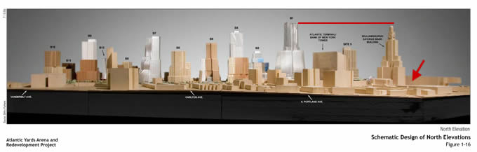
The northern view of the entire Atlantic Yards Development model
|
|
|
|
|
|
| In this slick photograph, the WIlliamsburgh Savings Bank building on the right appears taller than it should be – while the other buildings appear shorter in comparison. "Miss Brooklyn," the largest and ugliest building in the development, is actually 20% taller than the Williamsburgh Savings Bank. |
| Image provided by FCRC; Image Enhancement by Abby Weissman (The only supplementation to this image is the red arrow and line). |
|
|
| Click here to see a large PDF image of this supplemented model photograph |
|
|
|
|
|
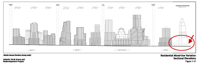
The elevation study from the northern South Oxford side
|
|
|
|
|
| The WIlliamsburgh Savings Bank on the right is standing on a raised platform – making it appear taller -- and making the other gigantic buildings appear shorter in comparison. "Miss Brooklyn," the development's biggest building, is 650' tall, while the Williamsburgh Savings Bank is 520' tall. In actuality the Bank should appear four-fifths as high as "Miss Brooklyn" – without the platform. Those two buildings, standing side-by-side, would be the disconcerting visual equivalent of a tacky overweight 6-foot 5-inch "bride" marrying a classy 5-foot 2-inch groom. You do the math. |
| Illustration provided by FCRC; Image Enhancement by Abby Weissman (The only supplementation to this image are the red arrow and circle). |
|
|
| Click here to see a large PDF image of this supplemented elevation drawing |
|
|
|
|
|
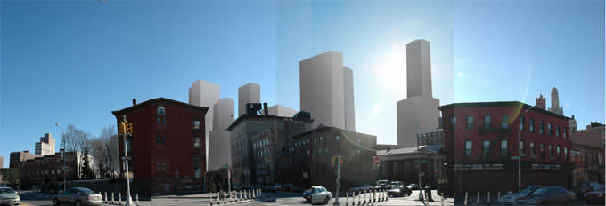
The post-construction view from South Oxford
and Fulton Streets (minus the shadows)
|
|
 |
|
| Click here to view the SouthOxford.com community-based Links section. |
|
Rendering of the corner of Fulton and South Oxford from www.onnyturf.com. Additional renderings are on the site.
|
|
|
|
Contrary what the Ratner people want you to think, the Atlantic Yards Development is NOT a done deal. It's important to express your opinion now to our local officials and representatives. Use our the handy links page.
|
|
|
| FROM THE ONE OF THE MANY INFORMATIVE ARTICLES ON THE DDDB WEB SITE: "The population density envisioned by Atlantic Yards in Brooklyn is between 436,363 and 523,636 inhabitants per square mile (based on estimated population of between 15,000 and 18,000 residents over 22 acres). That's more than the densest location in Manhattan - which according to the 2000 Census is a 1,190-unit former Mitchell-Lama building in Harlem that stands surrounded by numerous tenements. That two-block area has a population density equivalent to 229,713 inhabitants per square mile." |
|